

Truskmore SE cairn [Truskmore E cairn]
Good walks are even better shared.
G7647 : View E across moors from Truskmore SE Cairn, Dartry Mountains
Colin Park Photo source
Overview
Truskmore SE Cairn [Truskmore E Cairn] Overview
Truskmore SE cairn, standing proudly at 665 meters, offers not just a challenging hike but a rewarding experience filled with stunning views and rich history. Located in the Sligo Mountains, this Marilyn is a must-visit for outdoor enthusiasts and history buffs alike.
Geology
The geological makeup of Truskmore mainly consists of limestone, presenting intriguing karst landscapes alongside rolling hills that are a joy to explore. As you hike, pay attention to the unique rock formations and varied terrain that tell the story of the earth's history over millions of years.
Route Details
The Carrowkeel Loop provides a picturesque route to the summit and starts at the Carrowkeel passage tombs. This moderate trek spans 7 kilometers and typically takes around 3.5 hours to complete. You'll traverse through enchanting scenes that are steeped in history—all while getting your steps in!
Summit Features
Upon reaching the summit, you'll find a stone cairn that serves not just as a marker but as the perfect backdrop for your hiking selfies. The expansive views from here cannot be overstated—it's a sight that will stay with you long after you've descended.
Terrain
Expect a mix of rocky and grassy terrain with some unavoidable boggy patches. A good pair of hiking boots will help you keep your footing, especially if the Irish weather decides to be its unpredictable self.
Views
From the top, you are greeted with breathtaking views of Sligo Bay, Benbulben Mountain, and, on clear days, glimpses of the Atlantic Ocean. The best time to soak in these sights is during late spring or early autumn when the skies are at their brightest.
Hazards
Hikers should remain vigilant of the weather as it can change in an instant. Be wary of slippery sections and hidden bogs—it's best to tread carefully! Always let someone know your plans before embarking.
Nearby Summits
For those looking to extend their adventure, nearby peaks include Benbulben, also at 665 meters, known for its striking plateau shape, and Knocknarea at 327 meters, home to the passage tomb of Queen Maeve.
Access
Nearest Parking: At the Carrowkeel passage tombs.
Public Transport: Buses to Sligo town with local transport available to the trailhead.
Nearest Town: Sligo is approximately 15 km away, where you can find all necessary amenities.
Facilities
While the path doesn't offer facilities, Sligo town is your best bet for refreshments and restrooms.
History
The name Truskmore translates from Irish as 'the crossing of the sea,' echoing the historical significance in local folklore.
In conclusion, Truskmore SE cairn is not just about reaching a peak; it's an adventure through time, nature, and wonderful views that make every step worthwhile. Happy hiking!
Explore routes near Truskmore SE cairn [Truskmore E cairn]
Walks starting near this hill. Open a route to check its map, distance and full itinerary.
Route planning notes
These notes describe possible approaches. Check a route's map and access information when planning your walk.
Carrowkeel Loop
A scenic loop starting from the Carrowkeel passage tombs, it offers an engaging combination of history and nature, leading hikers towards the summit while enjoying panoramic views of the surrounding countryside.
Make a day of it, together
Find someone to share the walk with, or organise a day out along a route you like.
Photo Gallery
View all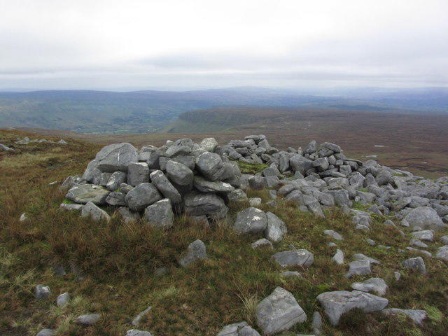 Photo could not load
G7647 : View E across moors from Truskmore SE Cairn, Dartry Mountains
Colin Park
Hill facts and local notes
Classifications
Elevation
631m
2,070 ft
Prominence
2m
Coordinates
54.3720, -8.3653
G763470
OS Map
16
At the Summit
The summit is marked by a distinct stone cairn, providing a perfect spot for a photo opportunity, paired with a breathtaking view of the rolling hills and valleys below.
Terrain & Geology
Dominantly composed of sedimentary rock, primarily limestone, the area features rolling landscapes and unique karst formations. The limestone creates a fascinating terrain full of interesting features, including limestone pavements and dolines.
Views & Scenery
From the summit, you can look out over Sligo Bay, Benbulben Mountain, and even catch glimpses of the Atlantic Ocean on a clear day.
History & Heritage
Name Origin
The name 'Truskmore' is derived from the Irish 'Tras Mhar', which means 'the crossing of the sea', echoing the region's deep cultural connections.
Historical Significance
Truskmore is steeped in local folklore, often associated with ancient rituals and sacred sites, particularly the nearby tombs that date back thousands of years.
Getting There & Facilities
Parking
Parking is available near the Carrowkeel passage tombs. It's a small car park but can accommodate several vehicles.
Public Transport
The nearest public transport connections are from Sligo town. Buses run regularly, and you can arrange local transport to the trailhead.
Nearby Facilities
There are no facilities directly at the trailhead. The nearest cafes and toilets can be found in Sligo town, approximately 15 km away.
Safety Information
Known Hazards
- Beware of changes in weather; conditions can turn quickly, and the terrain can be slippery after rain. Also, watch for hidden bogs!
General Safety Tips
- Check weather conditions before setting out
- Carry appropriate clothing and equipment
- Let someone know your planned route
- Take a map, compass, and GPS device
- Carry emergency supplies: food, water, first aid kit, torch
Hills
Some common questions about the hills answered
Are there group walks up Truskmore SE cairn [Truskmore E cairn]?
Many walkers use Walkmates to join or organise walks with others. You can check for group walks around Truskmore SE cairn [Truskmore E cairn] through the maps
Are there other walkers around Truskmore SE cairn [Truskmore E cairn]?
Activity varies by location and time, but Walkmates lets you see whether others have shared walks or shown interest in this area. Find other people through the walking friends search walking friends for Truskmore SE cairn [Truskmore E cairn] search or of course create your own walk for Truskmore SE cairn [Truskmore E cairn]
Can I organise a walk to Truskmore SE cairn [Truskmore E cairn]?
Yes. If there aren’t any walks listed already, you can create a walk and make it available for others to join.
If you're signed up to Walkmates, you can create a walk to Truskmore SE cairn [Truskmore E cairn].
How do I find a walk up this hill?
There are often multiple ways to walk this hill, depending on experience and route preference. Walkmates helps you explore walks and routes that others have shared.
Can I suggest a new route up Truskmore SE cairn [Truskmore E cairn]?
Yes. You can suggest or create routes to share with others. Walkmates focuses on the social side of walking, so routes are used to help people organise walks and explore areas together, rather than as detailed navigation tools or route libraries.
Other uses really appreciate knowledgeable walkers sharing their routes. Share your favourite route to Truskmore SE cairn [Truskmore E cairn] here
The is an error or something incorrect about this hill. How do I let you know?
We always strive to keep the information on Walkmates as accurate as possible. If you find an error, please let us know through the contact form and we'll aim to correct it as quickly as possible
Community Discussion
Comments
Location
View the hill's mapped position and surrounding paths.
Grid reference: G763470
View on OpenStreetMapOpens a map in a new tab, centred on the hill.
No comments yet. Be the first.